Bigbury-on-Sea South West Coast Path Walk, Bigbury-on-Sea, South Devon

The South West Coast Path at Bigbury-on-Sea
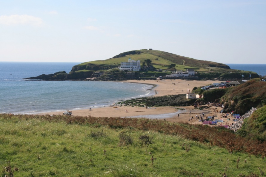
Burgh Island, Bigbury-on-Sea and Bantham combine to form an iconic South Devon holiday destination. Great beaches, pubs, watersports and beauty attract high numbers of visitors. It's also a top area for coastal, countryside and estuary walking. Whilst not flat, the terrain is relatively gentle and the coast path connects two remarkable South Devon estuaries.
Walking Burgh Island before heading out on the South West Coast Path
Before heading east or west on the South West Coast Path from Bigbury-on-Sea, loop around Burgh Island with its famous Burgh Island Hotel and The Pilchard Inn. The views from the top of the tidal island to the coastlines you'll be walking are stunning.
Start from the large car park above Bigbury-on-Sea Beach. Drop down to the sand that connects Bigbury-on-Sea and Burgh Island. Note that at high tide this neck of sand is covered in water so you have to take the Burgh Island Sea Tractor. Paths climb from The Pilchard Inn to the top, and then around the side, of the island.
Walking the South West Coast Path east of Bigbury-on-Sea
The section of the coast path between the River Avon and Estuary and South Milton Sands/Thurlestone Sand (Beach) is one of the best in South Devon. If you're on holiday in the Bigbury-on-Sea area then make sure you walk it in both directions to make the most of the views.
Start from the large car park above Bigbury-on-Sea Beach. Follow the B3392 main access road out of Bigbury-on-Sea. At the edge of the village, you'll see the South West Coast Path to your right. Drop down to the Bigbury-on-Sea/Bantham Ferry. Take the ferry across the River Avon and Estuary. Local South West Coast Path information boards read: 'River Avon. The ferry runs Mon-Sat, 10-11am and 3-4pm from 19th April until 21st September 2019. There is no Sunday service.'
When on the east side of the River Avon and Estuary, follow the road down to the car park behind Bantham Beach. There are public toilets here. The South West Coast Path heads up to the cliffs. The views back to Burgh Island are sensational. The path takes you along the edge of Thurlestone Golf Club to Thurlestone Island Sands/Thurlestone Golf Course Beach before looping around Warren Point to Thurlestone Leas Foot Sand (Beach). You continue over a headland to the glorious South Milton Sands/Thurlestone Sand (Beach). Stop at the beachhouse cafe and bar for a drink.
Return on the same route to enjoy the views in the other direction.
The Avon Estuary Walk
If you're on holiday in Bigbury-on-Sea out of season, or if you miss the ferry, you can follow the Avon Estuary Walk around Avon Estuary via Aveton Gifford. About 10 km/6 miles and 2 hours 30 mins walking, it's a long detour and a great walk in its own right.
Start from the large car park above Bigbury-on-Sea Beach. Follow the Avon Estuary Walk all the way up the west side of the River Avon and Estuary to Milburn Orchard. There's a pretty tidal road that takes you to Aveton Gifford Bridge on which you cross the River Avon. Note that there's an additional loop avoiding this tidal road when the tide's in! The path then runs down the west side of the River Avon and Estuary to Bantham and The Sloop Inn. You connect with the South West Coast Path at this point.
Walking the South West Coast Path west of Bigbury-on-Sea
Start from the large car park above Bigbury-on-Sea Beach. A short stretch of coast path skirts the front of Bigbury-on-Sea and takes you to Challaborough Beach. The South West Coast Path then climbs to cliffs that lead to the beautiful Ayrmer Cove (Beach).
The path rises from Ayrmer Cove (Beach) and runs along a short section of cliffs before descending steeply to the back of Westcombe Beach (alternatively Wiscombe/Wyscombe Beach).
The South West Coast Path then climbs again to a long stretch of relatively high cliffs that runs above lots of inaccessible coves and takes you to the mouth of the River Erme and Estuary. At low tide, this is a huge area of sand with Dartmoor National Park's south moor visible in the distance.
Whilst you can walk back in the direction from which you came, we'd recommend following the South West Coast Path along the east side of the River Erme and Estuary to the slipway by the access road. A path takes you inland to Kingston and The Dolphin Inn. You then follow the valley down to the coast at Westcombe Beach (Wiscombe/Wyscombe Beach). Return to Bigbury-on-Sea on the South West Coast Path.
Alternatively, another path runs from Kingston to Ringmore and The Journey's End Inn. A path takes you down to Ayrmer Cove (Beach). Again, return to Bigbury-on-Sea on the South West Coast Path.
Crossing the River Erme and Estuary
Note that if you want to continue west on the South West Coast Path, you need to cross the River Erme and Estuary. This takes you to Coastguard's Beach and Mothecombe (Meadowsfoot) Beach.
Local information boards read: 'The River Erme can usually be waded for 1 hour either side of low tide by crossing between the two slipways as shown on the photograph. However care should be taken as heavy rains or seas can make the crossing dangerous. The times of low water are shown in the table below. Also provided, for when it's not possible to ford the river, are directions for walking around it and phone numbers for local taxi firms.
Walking around the river. As there are no public footpaths running along the sides of the estuary this entails a 7 mile walk mainly on country lanes.'
Photo Gallery